In the second part we add detailed information about the individual
connections. We can do that for all of the connections or just the selected
ones. The detailed info for one connection looks like this:
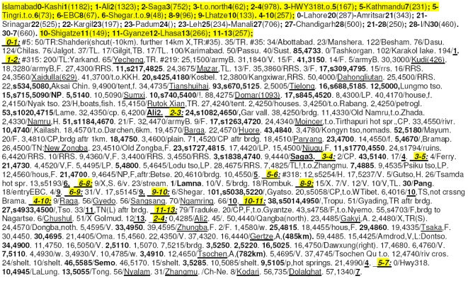
1-2: #315: 200/TL:Yarkand. 65/Yecheng,TR. #219: 25,1500/armyB.
31,1840/V. 15/F. 41,3150. 14/F. 5/armyB. 30,3000/Kudi(426). 18,3280/armyB,F.
27,4300/RRS. 11,s217,4825. 24,3675/Mazar,TL.
13/F. 35,3860/RRS. 3/F. 17,s309,4795. 15/rrs. 16/RRS.
24,3560/Xaidulla(629).
41,3700/t.o.KKH. 20,s425,4180/Kosbel. 12,3800/Kangxiwar,RRS.
50,4000/Dahongliutan. 25,4500/RRS. 22,s534,5080,Aksai Chin. 9,4900/tent,f.
34,4735/Tianshuihai. 93,s670,5125. 2,5005/Tielong. 16,s688,5185.
12,5000,Lungmo tso. 15,s715,5090/NP. 5,5140. 10,5090/Sumxi.
10,s740,5400/!.
88,4275/Domar(1093). 17,s845,4520. 8,4300/LP. 40,4170/house,f. 2,4150/Nyak
tso. 23/H,boats,fish. 15,4150/Rutok Xian,TR. 27,4240/tent. 2,4250/houses.
3,4250/t.o.Rabang. 2,4250/petrogl. 53,s1020,4715/Lame. 32,4350/cp.
6,4200/Ali2.
The meaning of it is as follows:
1-2:                   info on connection 1-2 (Kashi-Ali) follows.
#315:                  road number 315.
200/TL:Yarkand.        after 200 km turn left for Yarkand.
65/Yecheng,TR.         65 km to Yecheng, after that turn right.
#219:                  road number 219.
25,1500/armyB.         25 km to army base, it's at the altitude 1500 m.
31,1840/V.             31 km to a village, its altitude is 1840 m.
15/F.                  15 km to guaranteed food.
41,3150.               after 41 km there is a pass, at 3150 m a.s.l. Passes are represented in bold.
14/f.                  after 14 km there is probable food
5/armyB.               5 km to army base.
30,3000/Kudi(426),CP.  30 km to Kudi. Kudi is at 3000 m altitude and 426 km from the starting point of this connection (e.g. from Kashi).
                       There is also a Checkpoint.
18,3280/armyB,F.       18 km to army base at altitude 3280 m and guaranteed food.
27,4300/RRS.           27 km to Road Repair Station, at 4300 m.
11,s217,4825.          11 km to a pass at 4825 a.s.l. There is a stone kilometer marker "217" at the top.
24,3675/Mazar,TL.      24 km to Mazar, at 3675 m. Mazar is underlined, which means you can get everything there (water, food, accomodation).
                       After Mazar turn left.
...
The extent of the detail for individual connections can be different. For
difficult routes like the above one, you need detail on food points and
altitude. For an easy connection only a connection length may be needed, all
other info may not be necessary or might be found while cycling the road itself.
The info on all of the usual connections in Hymalaya region can be stored
on a card with dimensions 13x8 cm - for a person with good eyesight, that is.
The front page of this card would look like this:
 The opposite side would have info on connections in India and Nepal (between
Lahore, Amritsar, Srinagar, Leh, Delhi and Kathmandu). There would be
enough space left on that side for personal info and few grace-saving chinese
phrases.
The opposite side would have info on connections in India and Nepal (between
Lahore, Amritsar, Srinagar, Leh, Delhi and Kathmandu). There would be
enough space left on that side for personal info and few grace-saving chinese
phrases.