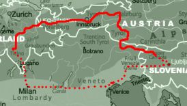
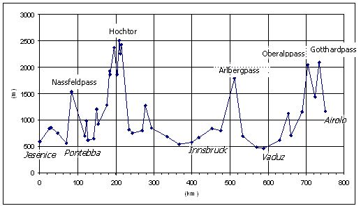
#17:

trip dates 27.4.2007 - 4.5.2007
distance cycled 750 km
repairs 0x


photos general info gear statistics travelogue     home page

A struggle in the Alps ... all because of a name

And this name was the name of the bicycle: "St Gothard" is written on its top tube. So, a little excursion to the famous Gotthardpass in Switzerland was called for. This bike was far from appropriate for mountain rides; it got attention because of its name ... and history. Read more about it in the blog.
General information
ROUTE: I took a train from Ljubljana to Jesenice in northwest Slovenia, where i started cycling. Crossed the border into Italy, down to Pontebba and then across Nassfeldpass into Austria. The ride through Austria: Kotschach, Grossglockner, Mittersill, Kitzbuhl, Schwatz, Innsbruck, Arlbergpass, Fielkirch. Then a short crossing of Lichenstein and into Switzerland: Chur, Ilanz, Disentis, Oberalppass, Andermatt, Gotthardpass. I ended in Airolo from where i took trains (Bellinzona-Milano-Mestre-Gorizia) and a bus (Nova Gorica - Ljubljana).

ROADS: Good roads, asphalt all the way. Down the Nassfeldpass they have some very rough stretches where a firm grip of the handlebar is a must.

MAPS: I am taken by the no-map approach now. I planned the trip by the map of the Alp region (1:500,000). I sqeezed the information from the map (places, directions, distances, road numbers) on a piece of paper (7x4 cm) which I plastified and wore in the back pocket of the cycling jersey. When producing the card I still have to make a bit more effort in accuracy (exact distances, altitudes) and to include some information of the routes that branch away from the planned itinerary, but on a whole, I can tell that this approach really works.

TRAFFIC: Well, it's there. Althou the drivers - especially the Austrians - are quite considerate (they give enough room when overtaking, will wait behind when it's not safe to pass), there still is a nervous feeling of vulnerability with all the cars zooming past you. In the high Alps the traffic thins out, so one more reason to hit the mountains. There are cycling paths in Austria and, as it seems, a net of peaceful roads that covers whole of Switzerland - a perfect option for those who are not pressed for time or speed.

PUBLIC TRANSPORT: Many trains will take bicycles. These are marked with special bicycle signs in schedules. The buses in Slovenia take bikes too if they have space - which is almost always the case.

ACCOMMODATION: In Austria every village has two or three houses, nicely marked, that will give you a bed and breakfast - costs from 20 to 30 euros. Just look out for the "Zimmer" signs as you spin along. Switzerland relies more on hotels, which are more expensive if they're not closed. I didn't have the tent but had spotted a few possible places for wild camping.

FOOD AND WATER: Food is readily available at restorants and stores. Water can be taken from streams high in the mountains. I didn't eat much. Hardly anything except a few breakfasts. Maybe that was the cause of some mild illness on the 3rd and 4th day.

COSTS: My most expensive tour - partly also because I didn't camp. I paid from 22 to 60 Euro for a bed&breakfast, spent 60 EUR/day. On the second thought: it was my cheapest tour - no expence for plane tickets.

VISAS: It was nice to travel around without the passport - only an ID-card is needed for the cytisens of Europe.

WEATHER: I might say I was lucky. One strom got me at the Gotthard pass - my final destination - and the other, before the Arlberg pass, I waited over. I planned to cycle back at least part of the way, but the forecast of three days of rain made me change the mind.

SITES: The high Alps are amazing, just like any mountains. I'm not much into cultural/hystoric sightseeing any more, although I must say old Innsbruck quarter is worth a look.

ANNOYANCES: Nothing to say here.

EQUIPMENT: A road bike with too high gears for the mountains. Very little more - the least so far in fact, only 2900 grams. Details are at the famous weight page.

REPAIRS: Left peddal fell off. Few threads were stripped, but screwing the peddal back was enough to get me through another 350 km.

LINKS: Trento pages should have at least a travelogue or two for every European country.
Profiles of European passes are quite useful for planning such a trip.


Nomen est omen

Zakaj vzeti bicikl z eno sprednjo šajbo in največjim zadnjim zobnikom s 24 zobmi za turo po Alpah? Odgovor je preprost: zato ker se bicikl imenuje "St Gothard". In še zraven tega ima neobičajno zgodovino. Preberi kaj več o tem v blogu.
Splošne informacije
POT: Iz Ljubljane to Jesenic z vlakom, nato v Italijo mimo Trbiža do Pontebe in nato gor v prelaz Nassfeld. V Avstiji sem vozil čez kraje: Kotschach, Grossglocknerpass, Mittersill, Kitzbuhl, Schwatz, Innsbruck, Arlbergpass, Fielkirch. Nako kratka pot skozi Liechenstein in po Švici: Chur, Ilanz, Disentis, Oberalppass, Andermatt, Gotthardpass. Turo sem končal v Airolu, od tam pa me je deževna fronta prisilila, da sem si privoščil vlake (Airolo-Bellinzona-Milano-Mestre-Gorizia) in avtobus (Nova Gorica - Ljubljana).

CESTE: Dobre, asfalt je povsod. No, izjema je spust z Nassfelda, kjer je cesta toliko valovita, da je treba čvrsto prijeti kolo, da kam ne uide.

ZEMLJEVID: Sedaj sem dokončno šarmiran z brezkartnim pristopom (prvič sem to sprobal v Indiji). Pot sem splaniral po karti Alp (1:500,000) in vse pomembnejše informacije z nje (kraje, smeri, razdalje, številke cest) stlačil na košček papirja (7x4 cm), ki sem ga plastifiral in nosil v žepu majice. Nekaj več truda bo v bodoče treba posvetiti natančnosti (točne razdalje, višine) in vključiti tudi osnovne informacije o poteh izven strogo planirane smeri, toda v splošnem je to - to. Časi ko sem potoval z zemljevidom so praktično končani.

PROMET: Brez tega, na žalost ne gre. Vozniki so sicer uvidevni - posebno Avstrijci - (prehitevajo na široko in so sposobni celo počakati za tabo, če je za to prenevarno), a še vedno imaš zoprn občutek ranljivosti, ko vse te škatle letijo mimo tebe. Višje v Alpah se promet stanjša - še en razlog več za kolesarjenje po hribih. Za tiste, ki jih hitrost (tj. počasnost) in čas ne omejujeta, so v Avstriji kolesarke steze, v Švici pa baje cel sistem kolesarjem prijaznih poti, ki prepredajo celo državo.

JAVNI TRANSPORT: Kolesa lahko prevažaš z veliko vlaki - ti so označeni s simbolom kolesa v voznih redih. Prijetno sem bil presenečen, ko je voznik avtobusa v Sloveniji brez ugovorov vzel kolo v spodnji prtljažnik. Celo vprašal me je ali jaz tudi potujem (!) - očitno se ga da poslati tudi nespremljano.

PRENOČIŠČA: Vsaka vas v Austriji ima dve ali tri hiše, ki oddajajo sobe z zajtrkom - stane med 22 in 31 EUR. Samo glej kjer piše "Zimmer". V Švici bolj prisegajo na hotele, ki so dražji, če že niso zaprti. Šotora nisem imel, a sem uočil kar nekaj primernih mest za kampiranje na divje.

HRANA IN VODA: S stem seveda ni problemov, pa naj gre za restavracije, markete ali bencinske postaje. Višje v Alpah lahko piješ vodo iz potočkov.

STROŠKI: Moja najdražja tura doslej - tudi zato, ker nisem kampiral. Za sobo z zajtrom sem plačal med 22 in 60 Euri, zaprail pa skupaj 60 Eur na dan. Pravzaprav, če bolje pomislim, je to moja najcenejša tura, če upoštevam, da ni bilo treba plačati letalske karte.

VIZE: Tokrat nisem rabil niti potnega lista - v Liechenstein in Švico prideš tudi z osebno.

VREME: Kljub problemom v zadnjem dnevu mislim, da sem imel srečo. Bogovi so mi namenili težak zaključek poti s snežnim metežem na vrhu Gottharda, a sem ga preživel, prav tako kot nevihto pred Arlbergom, ki sem jo prečepel v hotelski garaži. Ciklon, ki se je tri dni vrtel na jugu Alp, me je vseeno prisil, da sem nazaj prišel z vlaki.

KRAJI: Alpski prelazi so najlepši del. Nisem več toliko zagret za kulturno-zgodovinske spomenike, a vseeno lahko rečem, da si je stari del Innsbrucka le potrebno ogledati.

NEVŠEČNOSTI: Nič.

OPREMA: Staro cestno kolo z za hribe previsokimi prestavami. Ostalo se je dalo stisniti v 2900 gramov - najmanj doslej. Glej detajle na zdaj že znameniti strani "weight".

POPRAVKI: Leva pedala mi je padla dol. S seboj je postrgala nekaj navojev, a sem jo odločno privil nazaj, tako, da je zdržala do konca.

LINKS: Trento bikes ima gotovo potopis ali dva za vsako evropsko državo (pa i šire).
Profili evropskih prelazov pridejo prav pri planiranju, in pri preklinjanju (njihove netočnosti), ko si enkrat tam.

Stuff

This bicycle had a history of its own - read about it in the summary and the blog. It was an old steel road bike with 2 front rings (52/42) and 6 speed freewheel (11-24). Expecting a tough tour with a lot of climbing, I removed the big front ring, front derailleur and shifter, changed the peddals for lighter plastic ones and stripped some minor accessories like wheel reflectors, a mirror and a bell. After this modification the bike weighed 10.9 kg, or 670 g less then originally. I didn't use racks (front or rear) and carried things in jersey pockets, in a small underseat bag attached to the hadlebar and bulkier stuff (trousers, fleece pullover) in a bag attached to the seatpost. All the stuff, complete with bags and shoes, weighed 2.9 kg, and together with water, food and the bike about 15 kg. The complete list is on the famous weight page.


Stvari

Bicikel je imel svojo zgodovino - o tem lahko prebereš v potopisu (klikni ikono z notesom). To je bilo staro jekleno cestno kolo z dvema šajbama spredaj (52/42) in 6-imi zobniki zadaj (11-24). V pričakovanju težke gorske ture sem odstranil veliki sprednji zobnik, sprednji menjalnik, zamenjal obupno čokate pedale, in se otresel še nekaj malenkosti kot so odsevniki, zrcalo in zvonec. Po vsem tem je bicikel tehtal 10.9 kg ali 670 gramov manj kot prej. Nisem uporabljal prtljažnikov in sem stvari nosil v žepih majice, majhni torbici na balanci, večje stvari kot hlače in pulover pa v vreči privezani za sedežem. Vse stvari, vključno s čevlji in vrečami, so tehtale 2900 g, skupaj z vodo, hrano (ki je praktično ni bilo) in kolesom pa okoli 15 kg. Celoten seznam glej tu.

Route profile


Cycling data


Day Date Trip Time   Speed  Climb Alti Total Accom Notes (daily end-stop) ***
                    Avr Max            
    d/m   km  h:m  km/h km/h    m    m    km
1  27/4  126  6:15 20.2 51.3 1435  622   126   h   Oberdrauburg
2  28/4  108  6:49 15.8 53.5 2910  821   234   h   Fusch
3  29/4  164  7:05 23.2 51.5  475  579   398   h   Innsbruck
4  30/4  136  6:48 20.1 51.3 1256  699   534   h   Braz
5   1/5  126  7:12 17.5 53.1  666  705   660   h   Ilanz
6   2/5   90  6:01 15.0 50.2 1988 1166   750   h   Airolo
7   3/5    0  0:0   0.0  0.0    0    0   750   h   Airolo-Mestre by train
8   4/5    0  0:0   0.0  0.0    0    0   750   -   Mestre-Ljubljana by train+bus

Days Trip Time Speed Climb Alti Avr Max km h:m km/h km/h m m 8 750 40:10 - - 8730 - Sum 6 750 40:10 - - 8730 - Sum, cycling days - 164 7:12 23.2 53.5 2910 1166 MAX, cycling days - 90 6:01 15.0 50.2 475 622 min, cycling days 8 94 5:01 14.0 38.8 1091 - average per day 6 125 6:42 18.7 51.8 1455 - average per cycling day
*** Legend 1 27/4 - cycling day 7 3/5 - non cycling or rest day Trip - daily cycling distance Time - daily cycling time (while in motion) Speed - daily cycling speed (while in motion): Avr - average; Max - maximal. Climb - daily cumulative altitude gain (registered manually) Alti - altitude at the end of the day Total - cumulative distance Accom - accommodation: a: airplane; b: bus; h: ho(s)tel; f: at a family; c: camp; w: wild camping

Travelogue

I wrote a blog on this trip, it's here: http://stgotthard.blogspot.com.


Potopis

Med potjo sem pisal "blog", a samo v angleščini. Glej: http://stgotthard.blogspot.com.