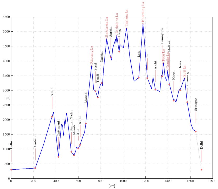
#18:

trip dates 6.8.2006 - 27.8.2006
distance cycled 1700 km
repairs 2x


photos general info gear statistics travelogue     home page

India: cycling from Hell to Heaven ... and back

Most cyclists heading to Indian Himalaya take a train from Delhi to Simla, to excape the heat, the traffic and the chaos. Cycling all the way is like a purifying pilgrimage from the heat and dust of the overpopulated planes to the virgin mountain peaks. Getting back is like comming from a dream back to reality. Both were exceptional experience.
General information
ROUTE: I started right from the Delhi airport. After struggling my way through the city I found Grand Trunk Road (#1) and followed it up to Ambala and past Chandigarh, then on road #22 to Simla, where I took a shortcut (frankly a longcut) through Tattapani and Rohanda, joining #21 at Sundar Nadar. From there it was straight on #21 to Mandi and Manali and then on the famous Manali-Leh highway. I rode up to Khardung La and back to Leh, then proceeded towards Pakistan through Kargil, Drass, Sonamarg and ending the cycling in Srinagar where I took a bus back to Delhi.

ROADS: Down in the plain the roads are smooth, with the exception of stretches through bigger towns, where all the dirt congregates. Up in the mountains it's about 80% of asphalt (which is sometimes good, other times rough or patched) and the rest is gravel, stones, mud and fords - bad parts are frequently near the top of the passes.

MAPS: This was a fun experiment. I planned the trip by the Nelles map of Northern India (1:1,500,000). I made notes of the towns, directions, distances and road numbers, all on a small card (10x6 cm) which I plastified and wore in the back pocket of the cycling jersey. I didn't take the map, but took photos of it and uploaded them on my e-mail account - just in case. I thought that this would have some benefit in reducing bulk and a little weight (~60 g), but the main intention was not to be distracted by looking for and at the map. I estimated that it would give me advantage of about 5 km per day. The reality was a bit different: I was distracted by many other things, I took roads that were not on the card and in the end I even lost it. One thing I learned, though: I can do without the map quite comfortably.

TRAFFIC: You can't find the traffic like that anywhere in the world. In populated places it's pure madness, although, even here you will find some kind of system. Usualy it's the system of "first come first served". Despite all what I read and herd, I found out that the motorists comming behind you will not run over you, even if they're short on space. Your biggest problem will be overtaking all sort of slow creatures (animal or human) in front of you and nagotiating the ones that are moving toward you in the wrong direction.

PUBLIC TRANSPORT: Buses will take bicycles on the roof - expect to pay porters to put it there. At your final destination, you'll often have to take it down yourself. I had to pay additional 300 rupees for the bike, althou I don't know if this is the rule or I was just an easy victim. At the Delhi airport they insisted that my bike is wrapped in plastic - the facility for this is right there and costs 300 rupees.

ACCOMMODATION: There are hotels or guesthouses nearly everywhere. On Manali-Leh HWY there are big tents set in strategic locations (after the passes) where you can get a bed. You can easily do this kind of trip without the tent.

FOOD AND WATER: I liked the food even so it's quite basic: rice or chapatti (thin bread) combined with some sauce - usualy dhal (lentil sauce). Add a salad and water and you have your daily meal. Vegetarians will love it. The rest of us will love it too, just be prepared to loose some weight.

COSTS: I paid from 150 to 400 rupees (R) for a hotel. The exception was 500R for a room+dinner+breakfast in the houseboat in Srinagar's Naghin lake - probably the best deal I ever made on any trip. Meals are from 20R to 60R. Soft drink is 25R, beer 70R to 120R, if you can find one. I spent 11US$/day.

VISAS: I got multiple entry Indian visa valid for 6 months (starting from the day of issue) through travel agency "Kompas" - cost me 105$.

WEATHER: It's hot and humid in Delhi and the plains. August is still monsoon time, even though I experienced surprisingly little rain. Most of it falls at night. Ladakh and Kashmir are mostly dry. Temperatures in the mountains were from 5 C at night to 33 C in daytime. Daylight from 6:00 to 19:00.

SITES: Amazing landscape, unbelievable (not always in a pleasant way) sights. I can't say more. Go there and witness it!

ANNOYANCES: You won't believe it, but - none! OK, to be honest, I had an incident, falling almost to the cellar throught the hole in the stairs, but it was my fault as I walked about in total darkness. Luckily I got away with only a scratch.

EQUIPMENT: Road bike and very little more. Click the bike icon above for details.

REPAIRS: 2 flat tyres. One of them - I am quite certain - was a deliberate puncture with a needle. The other one was a puncture from a piece of metal (a broken washer).

LINKS: Steve Pells provides the most extensive description of the Manali - Leh route. For other routes see: excellent Rich's blog (2006), Bill Weir's travelogues and Tracey Maund and Colin Champion's site (where further links are available).


Indijska Himalaja: s kolesom od pekla do nebes ... in nazaj

Splošne informacije
Večina kolesarjev, ki se odpravlja v Indjsko Himalajo vzame vlak iz Delhija do Simle, da se izogne vročini, prometu in kaosu. Prevoziti celo pot je podobno očiščevalni terapiji od vroče in prašne ravnine do deviških Himalajskih vrhov. Pot nazaj je kot bi se zbujal iz nedeljskih sanj v realnost službenega ponedeljka.

POT: Štartal sem iz samega Delhijskega letališča. Po tem ko sem se prebil skozi mesto sem našel Grand Trunk Road (#1) in ga sledil do Ambale, mimo Chandigarha, nato po cesti #22 do Simle, kjer sem usekal bližnjico (ali morebiti raje daljšnico) skozi Tattapani in Rohando, in se priključil #21 pri Sundar Nadarju. Od tam naravnost po #21 do Mandija in Manalija in nato po slavnem Manali-Leh highway. Brez prtljage sem se vzpel na Khardung La, nazaj do Leha, nato pa neustrašno proti Pakistanski meji skozi Kargil, Drass, Sonamarg in končal kolesarjenje srebajoč čaj v kraljevski plavajoči hiši v Srinagarju, od koder sem vzel avtobus nazaj v Delhi.

CESTE: V ravnini so gladke z izjemo delov skozi večja mesta, kjer se nabira vsa nesnaga. V hribih je okoli 80% asfalta (ki je včasih dober, včasih grob in luknjičast) ostalo pa je makadam, kamni, blato in potoki - slabi deli so običajno v bližini prelazov.

ZEMLJEVID: To je bil zabaven eksperiment. Pot sem načrtoval po Nellesovi karti Severne Indije (1:1,500,000). Zabeležil sem imena mest, smeri, razdalje in številke cest na majhen košček papirja (10x6 cm) ki sem ga plastificiral in nosil v žepu majice. Karte nisem vzel, za vsak slučaj sem jo fotografiral in slike naložil na internet. Misil sem, da mi bo to nekoliko zmanjšalo prtljago (okoli 60 gramov in veliko več prostora), toda glavni namen je bil da se ne ubadam z odpiranjem in zapiranjem in iskanjem poti na karti. Predvideval sem, da mi bo to prineslo okoli 5 km prednosti na dan. Realnost je bila nekoliko drugačna: ubadal sem se z veliko drugimi stvarmi, vozil sem po cestah, ki jih ni bilo na pipirju, na koncu sem ga celo izgubil. Eno stvar sem se pa le izučil: da zemljevida v bistvu sploh nujno ne rabim.

PROMET: Takega prometa ne boste našli drugje po svetu. V obljudennih krajih je popolna norija, čeprav tudi tu obstaja nek sistem, recimo "prvi prideš, prvi melješ". Navkljub vsemu kar sem prebral sem ugotovil, da vozniki ne bodo šli čez tebe, četudi so na tesnem s prostorom. Največji problem je prehitevanje počasnih vozil (človeških ali živalskih) in vožnja mimo tistih, ki ti prihajajo nasproti po narobni strani.

JAVNI TRANSPORT: Avtobusi bodo vzeli bicikl na vrh strehe - običajno boš moral plačati nosačem za to uslugo. Na končni destinaciji boš verjetmo moral sam dati kolo dol. Moral sem plačati dodatnih 300 rupij za prevoz kolesa, čeprav ne vem ali je to pravilo ali pa sem bil le lahka žrtev. Na Delhijskem letališču so insistirali, da zapakiram kolo v plastično folijo - to ti naredijo tam tudi za 300 rupij.

PRENOČIŠČA: Hoteli in gostišča so praktično povsod. Na cesti Manali-Leh so turistični šotori postavljeni na srateških lokacijah (pred in po prelazih) kjer lahko dobiš poceni posteljo. Zlahka lahko opraviš to pot brez šotora in spalne vreče.

HRANA IN VODA: Hrana mi je bila všeč, čeprav je precej bazična: riž ali chapatti (tenka lepinja) skupaj s kako omako - ponavadi dhal (lečina omaka). Dodaj solato in vodo in imaš svoj dnevni obrok. Vegetarijanci bodo navdušeni. Ostali tudi, le pričakuj, da boš izgubil nekaj kil.

STROŠKI: Plačeval sem med 150 in 400 rupijami (R) za hotel. Izjema je 500R za sobo+večerjo+zajtrk v plavajoči hišici na Nagin jezeru v Srinargarju - verjetno naboljša kupčija, ki sem jo kadarkoli naredil. Obroki so med 20R in 60R. Gazirana pijača je 25R, pivo 70R do 120R, če ga lahko najdeš. Zapravil sem 11US$/dan.

VIZE: Vizo za Indijo z večkratnim vstopom in veljavnostjo 6 mesecev (ki začne veljati z datumom izdaje) sem dobil preko Kompasa za 105$.

VREME: V Delhiju in v ravnini je vroče in soparno. Avgust je še vedno monsunski mesec, čeprav sem imel presenetljivo malo dežja. Večina ga pade ponoči. Ladakh in Kashmir sta v glavnem suha. Temperature v hribih so med 5 C po noči in 33 C podnevi. Svetlo je od 6:00 do 19:00.

KRAJI: Izjemna pokrajina, neverjetni prizori (ne vedno v prijetnem smislu). Ne morem reči kaj več - treba je iti in izkusiti.

NEVŠEČNOSTI: Nič. OK, če sem čisto odkrit, sem imel en incident, ko sem padel skozi luknjo v stopnicah. Bilo bi lahko precej hujše kot je, toda kriv sem si v glavnem sam, ker sem hodil okoli v totalni temi.

OPREMA: Cestno kolo in le malo kaj več. Glej detajle na zdaj že znameniti strani "weight".

POPRAVKI: 2 predrti zračnici. Za eno od njih sem trdno prepričan, da je maslo dečka iz šotora kjer sem prespal.

POVEZAVE: LINKS: Steve Pells ima najbolj detajlen opis poti Manali - Leh. Za ostale poti poglej: izvrsten Richov blog (2006), potopise Bill Weira in stran Tracey Maund in Colina Championa (kjer dobiš nadaljne linke).

Stuff

Aluminium road bike with carbon fork, triple chainring (52/42/30), 8 speed cassette (12-26) and tyres 700x32c on front, 700x25c at the back. Ultralight, as always, slightly above 7 kg of stuff, and slightly below 20 kg of everything: including bike, food, water and all of the rest, down to shoe laces (see The list). The least so far, thanks mostly to the digital camera, which helped me get rid of the big handlebar bag. The tent and the stuff bag with most of things wrapped in bubble wrap was on the rear rack, digital camera and few other things in a saddlebag attached to the handlebar. Note that this was not a 'credit card' trip - I had a tent and sleeping bag, even though I used them only twice.
With the exception of neckerchief I used all of the things. If I'd do it again, I'd go without the tent and sleeping bag.


Stvari

Cestno kolo št. 8, ki je sedaj moje standardno potovalno kolo. Ima aluminijasti okvir, karbonsko vilico, trojno šajbo (52/42/30) in 8-prestavno kaseto (12-26). Gume so bile 700x32c spredaj in 700x25c zadaj. Ultralahko, kot vedno, nekoliko nad 7 kg stvari in nekoliko pod 20 kg vsega: vključujoč kolo, hrano, vodo in vse ostalo dol do vezalk (glej seznam). Najmanj do zdaj, predvsem zaradi digitalnega fotoaparata, ki mi je omogočil, da se znebim velike torbe na balanci. Šotor in pakirna vreča z večino stvari zavitih v "bubble-wrap" folijo sta bila na zadnjem prtljažniku, digitalni fotoaparat in nekaj pogosto rabljenih stvari pa v majhni torbici na balanci. Pozor: to ni bila "credit-card" tura; imel sem šotor in spalno vrečo, četudi sem ju uporabil le dvakrat. Če bi še enkrat šel, ju ne bi vzel.

Route profile

Climbing data


Climb                         dH    dL      g

Manali-Rhotang La: 901 21 4,3 1056 30 3,5 average: 1952 51 3,8
Tandi-Baralacha La: 337 14 2,4 9 3 0,3 76 7 1,1 68 11 0,6 -100 15 -6,7 516 9 5,7 1085 29 3,7 average: 2091 73 2,9
Gata Loops-Nakee La: 406 11 3,7 303 25 1,2 average: 709 36 2,0
Whiskey Nullah-Lachalung La: 271 7 3,9
Pang-Moray plain: 238 7 3,4
Kar Tzo-Taglang La 659 28 2,4
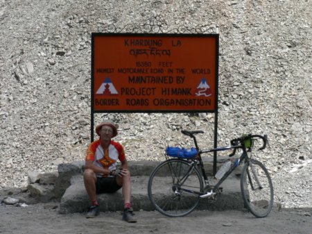
Leh-Khardung La: 1820 38 4,8
Indus-Lamayuru: 547 14 3,9
Lamayuru-Fotu La: 446 13 3,4
Namika La: 354 8 4,4
Drass-Zoji La: 386 36 1,1 13 4 0,3 average: 399 40 1,0
*** Legend dH: height difference [m] dL: distance difference [km] g: road gradient [%]

Cycling data


Day Date Trip Time   Speed  Climb Alti Total Accom Notes (daily end-stop) ***
                    Avr Max            
    d/m   km  h:m  km/h km/h    m    m    km
0   6/8    0  0:0   0.0  0.0    0   10     0   h   Ljubljana-Istanbul
1   7/8    0  0:0   0.0  0.0    0  300     0   a   Istanbul-Delhi
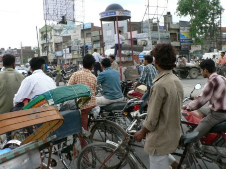
2   8/8  216  9:49 21.6 40.0   50  350   216   h   Ambala
3   9/8   74  4:23 17.0 34.2  802 1152   290   h   Simla -75km
4  10/8  132  8:00 16.5 41.7 1101  740   422   h   Tattapani
5  11/8  115  8:23 13.7 38.5 1993  910   537   h   Sundar Nadar
6  12/8  130  7:52 16.5 54.0 1123 1873   667   h   Manali
7  13/8   86  7:26 11.5 38.9 1957 2971   753   h   Sissu
8  14/8  110  9:33 11.5 40.5 2091 4527   863   h   Baratpur
9  15/8  101  7:50 12.5 41.8  980 4320   964   h   Pang
10 16/8   97  7:39 12.7 42.5  897 4088  1061   w   Rumtze -2 km
11 17/8   78  4:08 18.9 44.0  125 3430  1139   h   Leh
12 18/8    0  0:0   0.0  0.0    0 3430  1139   h   Leh
13 19/8   77  6:06 12.6 44.7 1820 3430  1216   h   Leh-Khardung La-Leh
14 20/8  131  8:02 16.3 43.5  931 3480  1347   w   Lamayuru
15 21/8  103  6:08 16.8 42.6  800 2654  1450   h   Kargil
16 22/8  121  8:39 14.0 47.5  856 2602  1571   h   Sonamarg
17 23/8   76  3:18 23.4 49.5    0 1603  1647   h   Srinagar
18 24/8   10  0:36 16.6 31.8    0  300  1657   b   Srinarag-Delhi
19 25/8    9  0:53 10.2 23.5    0  300  1666   h   Delhi
20 26/8   34  2:26 14.0 27.9    0  300  1700   a   Delhi
21 27/8    0  0:0   0.0  0.0    0  300  1700   a   Delhi-Istanbul-Ljubljana

Days Trip Time Speed Climb Alti Avr Max km h:m km/h km/h m m 22 1700 111:11 - - 15530 - Sum 15 1647 107:16 - - 15530 - Sum, cycling days - 216 9:49 23.4 54.0 2091 4527 MAX, cycling days - 74 4:08 11.5 34.2 50 300 min, cycling days 22 77 5:03 12.6 33.1 706 1958 average per day 15 110 7:09 15.7 42.9 1035 2542 average per cycling day
*** Legend 12 17/8 - cycling day 13 18/8 - non cycling or rest day Trip - daily cycling distance Time - daily cycling time (while in motion) Speed - daily cycling speed (while in motion): Avr - average; Max - maximal. Climb - daily cumulative altitude gain (registered manually) Alti - altitude at the end of the day Total - cumulative distance Accom - accommodation: a: airplane; b: bus; h: ho(s)tel; f: at a family; c: camp; w: wild camping

Travelogue

I wrote a blog on this trip, it's here: http://iikinindia.blogspot.com.
A full "photo-coverage" is at http://www.flickr.com/photos/24563480@N00/sets/72157594257325179/


Potopis

Blog v angleščini lahko vidiš na: http://iikinindia.blogspot.com.
Več fotografij s poti pa na http://www.flickr.com/photos/24563480@N00/sets/72157594257325179/