
The location of an object on the sky is fixed by celestial coordinates analogous to the terrestrial latitude/longitude system. There are various systems, suitable for different purposes; each needs a fundamental circle and a fixed point on it.
The simplest is the horizontal system, which uses
the horizon as its fundamental circle.
The poles of this circle are the zenith overhead and the nadir
underfoot; these are defined by the local vertical (using a plumb-line
or similar). Draw a vertical circle from the zenith to the nadir
through object X.
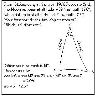
The altitude of object X is the angular distance along the vertical circle from the horizon to X, measured from -90° at nadir to +90° at zenith. Alternatively, the zenith distance of X is 90° - altitude. Any two objects with the same altitude lie on a small circle called a parallel of altitude.
To fix a point of origin on horizon, we look at where the spin axis of the Earth intersects the celestial sphere, at the North and South Celestial Poles. The vertical circle through these is called the principal vertical. Where this intersects the horizon, it gives the north and south cardinal points (the north point is the one nearest the North Celestial Pole). Midway between these are the east and west cardinal points; the vertical circle through these is called the prime vertical, at 90° to the principal vertical.
The azimuth of object X is the angular distance around the horizon from the north cardinal point to the vertical circle through X, measured 0°-360° westwards (clockwise).
Note that the altitude of the North Celestial Pole is equal to the latitude of the observer.
Comparison with terrestrial system:
terrestrial
alt-az
equator
horizon
North Pole
zenith
South Pole
nadir
latitude
altitude
co-latitude
zenith distance
parallel of latitude parallel of altitude
meridian of longitude vertical circle
Greenwich Meridian Principal Vertical
longitude
azimuth
Return to index.