1. THE
ČABRANKA
(from Čabar to Osilnica, alt 600 m - 290 m)
The river is embraced by
a picturesque valley with magnificent steep banks and precipitous cliffs. The
Čabranka springs from an exurgence under the Podplanina village, then passes the
Draga village through the Dragarska dolina valley to come to the Loški Potok
village. After some kilometers the river bites into the high cliffs of the
Žurgarska and Taborska stena mountains, passes small settlements Pungert, Črni
Potok, Žurge, Papeži, Belica (in the past a stronghold against the Turks)
Bezgarji, Bezgovica Strojiči and shortly after that falls into the
Kolpa.
The
whole area of the Čabranka, including the Croatian part, was part of Carniola in
the past. In the l7th century it came under the rule of Croatian Frankopan, but
was nevertheless settled by the Kočevje Germans as well as Slovenes from Bohinj,
Železniki, Idrija.
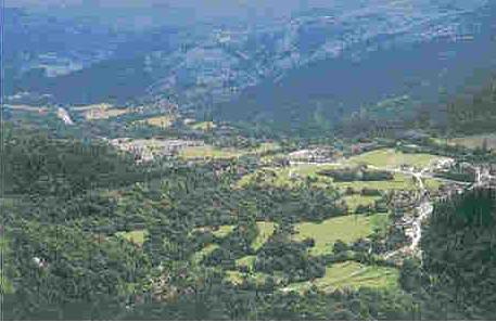
2. THE UPPER CANYON OF THE
KOLPA
(from Osilnica to Grivac, passing under the Borovška gora and
Kuželjska stena mountains; 287 m - 222 m; gradient 4.4%)
The monthly mean flow at
Osilnica is 22.6 m3/s; it is lowest in August (7.9 m3/s) and highest in
November (37.5 m3/s). It is exactly here, at the confluence with the
Čabranka, that the Kolpa reaches the Slovene bor- der and the valley widens to
several hundred meters to provide space for bigger settlements on both sides of
the border. On the Slovene side we have Osilnica, the biggest town in the area
with the old parish of St. Peter and St. Paul, next to Osilnica there is Sela
and above it the villages Križmani, Zgornji Čačič, Spodnji Čačič, Padovo near
Osilnica, and a bit further downstream Malinišče. Another slightly bigger town
is Ribjek with the old church of St. 6iles, followed by Ložec, which is
surrounded by the following mountains: Loška stena (alt. 876 m), Firstov rep
(alt. 1002 m), and Mož and Baba (alt. 1125 m). The latter two are lone-standing
rocky columns on the edge of the Borovniška gora mountain, a karstic plateau
boasting a virgin forrest, home of the chamois and alpine flora. Without a
doubt, owing to the gorgeous Jurassic and Cretaceous cliffs on the Slovene side,
this is the most beautiful and imposing part of the valley with the river
featuring numerous rapids. The line of rocky peaks and cliffs continues with the
Krokar (alt. 1122 m), Krempa (alt. 944 m), Borič (alt. 909 m), Kapič (alt. 905
m) and Kuželjska stena (alt. 874 m); below them the following settlements are
crowded: Grintovec near Osilnica, Bosljiva Loka with the subsidiary church of
St. Vitus, Mirtoviči, featuring the distinctive hill called Orlovski vrh with
the rock-sheltered cave Velika luknja, and Srobotnik on the Kolpa. Before we
reach Srobotnik, on a cut-off meander of the Kolpa, there is the lonely St.
Ann's church.
3. Kostel
(from Petrina to Kostel, alt. 222
m - 207 m)
|
The Kostel is a beautiful wide valley, resembling a natural amphitheater caught between high, steep slopes and somewhere even vertical cliffs of Jurassic and Cretaceous limestone. The Slovene side has almost 30 small settlements situated around the ancient parochial center Fara; it is right here that the priests of the primordial parish of Ribnica gathered as early as in the 14th century, while the whole area was ruled the by the Counts of the Kostel castle. |
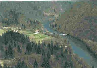 |
This is a genuine
river canyon, cut in the Jurassic and Cretaceous limestone strata, the
width of the river-bed not exceeding 100 meters and the steep, partly precipitous banks reaching 300-350 meters high. Only a couple of lonely houses, water-mills, forges and small villages indicate the continuous communication between the river and the higher placed settlements, in the past mostly inhabitated by the Kočevje Germans. Near the entrance to the canyon we find Dolenja Žaga, Gorenja Žaga and the boiling spring cave Kotnica (water supplied from the Kočevska Reka region), followed by Lobič, Žlebe, Grgelj and Spodnja Bilpa, featuring an imposing exurgence and rock-sheltered caves under a vertical cliff. |
 |
The lower stream in many ways resembles the upper, except that it is even wider under the old settlement of the "uskoki" Marindol and the Adlešiči parish: the bot- tom of the valley is 200 - 300 meters wide and the steep banks are about 50 - 70 meters high. The old Pobrežje castle is the strategic passage across the river, followed by the villages Dolenjci, Fučkovci and Dragoši. The banks are gradually becoming lower, reaching 10 - 20 meters of height. |
8. THE
FLATS' STREAM
(from Griblje to Radoviči; alt.
136 m - 132 m)
There is no trace of the shallow karst, the river runs through
Quartenary flooding flats from the villages Griblje and Krasinec to Podzemelj,
Zemelj and Otok. Close to the left bank you will find the attractive scenic-
view hill Kučar (alt. 222 m), a prehistoric post. The only tributary of Bela
Krajina, the lahinja, falls into the Kolpa at the village Primostek; the
following kilometer of the valley is narrow, because the Kolpa passes an area of
shallow karst. After that, at Log, it is opened into the Metlika flats and
passes Križevska vas and Metlika.
9. THE BOŽAKOVO
VALLEY
(alt 132 m - 124 m)
The Božakovska dolina is the last
narrow passage of the Kolpa before it enters the extensive Croatian flats with
meanders and swamps of the Panonia. Cretaceous strata of limestone facing south
provided the last barrier for the Kolpa to cut through, featuring a narrow
river-bed, with some 50 meters high banks under the village Božakovo. Through
this passage run: the ancient traftic connection between the Carniola and
Karlovac. Average annual flow of the river at this point is 76.3 m3, being
lowest in July (34.6 m3) and highest in December (108.7 m3).