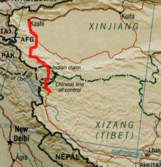
Route details
 |
The data on distances, altitudes, accomodation, food, road quality, PSB, etc.
included in this PDF file (150 kB) is all you need to navigate from Kashi to Lhasa.
The data is a compilation from web-sites of several cyclists (Res Blum, Martin
Adserballe, Janne Corax, ...) with a bit of my addition.
|  Razdalje, vi�ine, opombe o preno�i��ih, hrani, stanju cest, PSB i.t.d.,
navedene v PDF datoteki (150 kB), so najbolj�e informacije za navigacijo od
Kashija do Lhase. Podatki so vzeti od razli�nih biciklistov (Res Blum, Martin
Adserballe, Janne Corax, ...) z nekaj mojimi dodatki.
Razdalje, vi�ine, opombe o preno�i��ih, hrani, stanju cest, PSB i.t.d.,
navedene v PDF datoteki (150 kB), so najbolj�e informacije za navigacijo od
Kashija do Lhase. Podatki so vzeti od razli�nih biciklistov (Res Blum, Martin
Adserballe, Janne Corax, ...) z nekaj mojimi dodatki.
|
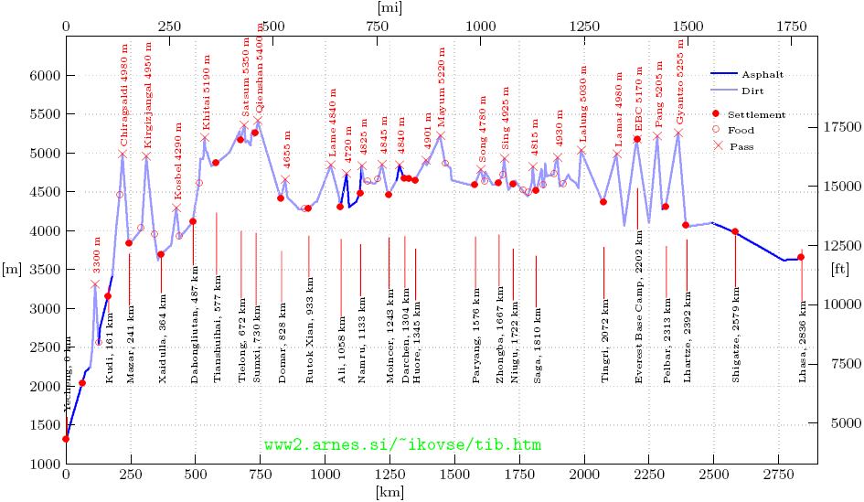
Route profile
Cycling data
Day Date Trip Total Accom Notes (daily end-stop) ***
    d/m   km    km
0  24/6    0      0   a   to Budapest by plane
1  25/6    0      0   a   to Beijing by plane
2  26/6    0      0   a   to Kashgar (Kashi) by plane
3  27/6  153    153   w   in the desert
4  28/6  157    310   w   after Yecheng
5  29/6  127    437   w   5 km before Kudi
6  30/6   59    496   f   RRS - 12 km before Chiragsaldi pass
7   1/7   61    557   w   20 km before Xaidulla pass
8   2/7   88    645   h   Xaidulla
9   3/7   81    726   w   before Kosbel pass
10  4/7   60    786   f   RRS, before Khitai pass
11  5/7   72    858   w   near Tianshuihai
12  6/7   79    937   w   after Tielong
13  7/7   82   1019   h   Sumxi
14  8/7   51   1070   f   40 km before Domar
15  9/7    0   1070   f   to Tielong by truck
16 10/7    0   1070   h   to Yecheng by truck
17 11/7    0   1070   h   to Kashi by bus
18 12/7    0   1070   h   Kashi
19 13/7    0   1070   a   to Beijing by plane
20 14/7    0   1070   h   Beijing
21 15/7    0   1070   a   to Ljubljana by plane

Days     Trip
          km
22      1070             Sum
12      1070             Sum, cycling days
 -       157             MAX
 -        51             min
 -        49             average per day
 -        89             average per cycling day

*** Legend
14  8/7 - cycling day
15  9/7 - non cycling or rest day
Trip    - daily cycling distance
Total   - cumulative distance
Accom   - accommodation: a:airplane; h:ho(s)tel; f:at a family; w:wild camping
Travelogue
Here are just few notes from this brief, misfortunate but still worthwile trip.
26.6.2005.
Life hasn't changed much here in Kashi. After 1 year I am sitting again
opposite the Seman Binguan and looking at the familiar sight of Uigur men
getting progressively drunk and mildly aggressive - but never beyond the point
of physical conflict. It all usually ends with a piss at the tree on the other
side of the street and a wobbling walk back home. I should be going to bed
myself, but the prospect of the big adventure which starts tomorrow keeps me
awake despite the three sleepless days which I spent criss-crossing the
Western and Eastern Paleartics. In the morning I wake up at 8:00, assemble the
bike by 9:00 and get ready by 10:00, so a plan of a monster 200 km starting
day has already gone down the drain. Even with this late start, I caught
myself half-asleep on the bike and several times I gave myself a big slap. The
problem that occupied my mind for the first two days was how to fix the rack
bolts which were constantly loosening. If this happens already on asphalt,
then what could I expect on the horror of the road 219? Finally in Yarkant I
bought a big screwdriver and few spare bolts and the problem vanished. This
part of the road consists of long desert stretches between poplar-lined oases.
It is essential that you stock with water regularly, as I realized too late,
with just 1 liter on the verge of the heat stroke in the mildly heated
Taklamakan oven blowing hot wind instead of refreshing breeze. I rode topless
until the evening and slept right under the stars, braving few lonely
mosquitoes rather than the suffocating heat of the tent.
The next day was quite similar - hot and flat. For two days now I've been
puzzled by the sight of a number of streams and two or three enormous rivers.
Huge amount of water was
coming from the mountains and I was afraid that the highlands were flooded and
impassable. In the afternoon of the second day I was standing beside the
significant road stone: G 219, km 1. The ouverture was over.
29.6.2005.
The km 93 stone marks the end of asphalt - finally the adventure
starts. Slowly the road rises and climbs the first pass. Just above 3000 m,
it was rather easy and joyful. And the downhill was exceptional. Not too fast
- 26 km/h was maximum that I allowed, I was still sceptical how my thin tyres
would react. To make it more fun, I raced with the red truck carrying the road
crew. Down at the valley there was another pleasant surprise: asphalt
returned. This was really a cream on top of this fantastic day: smooth riding
aided by the tailwind up the valley of a raging river which claimed several
bits
of a newly constructed road. The delightful ride lasted almost to Kudi,
where, 5 km before the village one big stream blocked the passage. After
consulting two shepherds, I decided to wait until morning when the water would
presumably drop.
Kudi - the place of my fears was ahead of me. If they turn me back at this
checkpoint, the great adventure would turn into a dull vacation. I stopped in
the village for a lamb soup and water refill. 500 m further there was a
red-white barrier and seemingly deserted booth. I tried to sneak around the
barreir and was stopped by three fierce dogs. Then a young soldier came
shaking his head, saying the word I'd rather not hear: "Permit". I kept the
calm and said I'd show my papers in the booth. There, a senior officer came
and after browsing through my passport for half a minute, he said "hao". The
young soldier raised the barrier and I raced beneath it holding the passport
in my teeth. Yesssssss, Tibet, here I come! The feeling pushed me 30 km
upward, until the hairpin dirt road of Chiragsaldi pass reminded me that I was
at the altitude above 4500 m, that I had a gearing of a road bike and that my
acclimatisation was totally lacking. After only 57 km I was dead tired, and
when I came to the RRS, I decided to make it my home for today.
During the night I was suffocating like a fish on a shore, had hardly had any
sleep and in the morning I noticed some symptoms of altitude sickness:
dizziness, headache, high hart beat rate and - scary - a hazy eyesight. I
continued slowly up to the summit (around 4900 m) and the symptoms started to
disappear. Downhill was fun again, I was swerving, vasling, dancing, joying
with incredible sights of amazing landscape of colorful cliffs and river beds.
2.7.2005.
The following days were rather undescriptive. The characteristic was somewhat
depressing weather. Gray clouds hanging close to the ground, frequent rain
during the night and several rain, snow or hail storms during the day, which
usually left me soaked. I
met another cyclist, a Chinese Michael Liu who had about 5 times as much
luggage as myself, all complete with the steam pot, where he cooked glass
noodles with pork rolls - a genuine Mandarin delicacy out of a military
rations, which we devoured in the evening and the next morning, complemented
with delicious stewed lichee. Thanks Michael!
5.7.2005.
It was the most miserable day of the trip. I started with 12 km climb up the
pass at 5050 m, the one that brings you into Aksai Chin. The day seemed good
at that moment, despite some steep sections where I chose to push the bike.
At the top the sky closed and then opened. The rain storm battered from
ahead. After the brief sun interval it continued from behind. I was soaked, my
gloves wet, and hands cramped started firing unusual nerve signals. When I
came near Tianshuihai I was lost between two roads, pedaling forth and back
in the rain, searching for a refuge. Finally I decided to retreat into an
abandoned building. To came to it I had to drag the bike up a muddy escarpment
resulting in clogged brake bridges and a kg of mud on my shoes. I was now
under the roof thoughtless, soaked to the bones and dirty. I
looked around the house: dust, rat shit, rotten potatoes and a smell of death:
there was no way I would spend the night here. I waited for the storm to stop.
Half an hour later I returned to the road, acquiring another kg of mud on my
bike and shoes in the process. After 15 min another storm began, but now, I
had it over the edge, I was furious. In the middle of the rain I put up a tent
and crawled in trying not to worry how I will be able to continue tomorrow.
From the warmth of my sleeping bag the things didn't look that desperate.
6.7.2005
The following days were similar: a wet-dry combination. I was mad at the
storms and rejoicing when the skies cleared. In the dry intervals I
enjoyed a fantastic sense of freedom in this vast, desert, silent scenary.
8.7.2005
This was a sad day. The day I had to break the trip. I woke up in the military
tent in Sumxi. A dozen of soldiers were still sleeping inside. The snow was
falling while I oiled the chain and then ate the breakfast, trying to delay
the departure in such a weather. When the snow stopped I went towards the
highest pass of
the whole West Tibet road, at 5250 meters (some say even 5400 m). The rains
from previous days left a mark on the road. There were lot of muddy stretches,
including the one at the very top of the pass where dozen of trucks were
stuck. I elegantly walked past them and resumed downhill. Yesterday I entered
Tibet, which looked considerably greener than what I was used to in Xinjiang.
Then again, a storm. I tried to hide from it behind the escarpment, which
sometimes works if the rain is swept by the wind. Not this time. There was a
tent in the distance and I approached. A young women with a child on her back
invited me inside. My first encounter with Tibetan nomads. Inside the tent it
was heaven: dry, warm, soft carpets on the ground and warm bowl of something
that I hoped was a yak-butter tea. It was good. The old man, with a look of
wisdom, indifference or ignorance, poured the tea, swinging his little praying
wheel. Just the two young men who were teasing each other couldn't fit into
this joyful serenity. It was utterly un-Tibetan, I guess they were not past
their initiation period. After a while the rain seemed to have stopped and I
took a farewell. As many times before the clouds closed around me in a form of
a horse-shoe, leaving bright skies ahead, which I chased into a drier land. I
found an excellent secondary road that lead into a gentle decline. The
tailwind was with me to give me speeds of up to 30 km/h and I started to
believe that Domar is within the today's reach. Not only Domar: Ali and all
subsequent places now started to seem attainable according to my plan. The
world was good.
Suddenly I was lying on my back. A memory of a previous portion of a second
was fading in my head - I just caught the thought that the bike was abruptly
stopped and I was catapulted. I felt my legs were OK and I stood up. My left
arm was OK too, I felt the pain in the right shoulder. I stripped the jacket
and the jersey and saw that the shoulder joint was unusually displaced. I
tried
to swing it back into position, but it didn't work. I could not lift the bike
with my right arm. I realized the game was over.
P.S. Two months later, having been thinking a lot about it, I'm certain now
that the accident occured when - mostly due to lack of sleep and rest caused
by poor acclimatization to high altitude - I lost consciousness for just a
moment.